Defence
The Night India Turned The Tables On China In Ladakh: Understanding The Kailash Range Operation
Prakhar Gupta
Feb 03, 2026, 12:54 PM | Updated 01:16 PM IST
Excerpts from former Army Chief General Manoj Naravane's unpublished memoir have triggered a political firestorm.
The excerpts describe a night in August 2020 when Indian and Chinese tanks faced each other barely a few hundred metres apart on the heights of the Kailash Range, and the Army Chief made "frantic calls" to political leadership asking for orders.
The memoir's claim that Defence Minister Rajnath Singh, after speaking with the Prime Minister, conveyed "Jo uchit samjho woh karo" (Do whatever you deem appropriate) has been seized upon by the Opposition as evidence of abdication at the highest levels.
The controversy has unfortunately obscured what should be the real story one of the most audacious military operations against China in recent decades.
On the intervening night of 29 and 30 August 2020, Indian forces preemptively occupied dominating heights on the Kailash Range south of Pangong Tso, territory they had not held since withdrawing under fire in 1962. This operation fundamentally altered the trajectory of the Ladakh standoff and forced China to the negotiating table.
The Geography That Shapes Everything
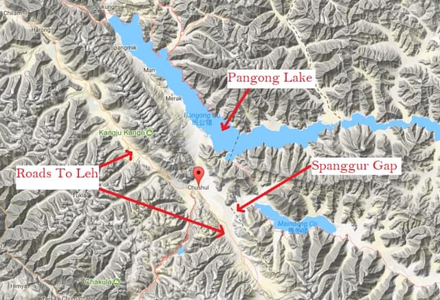
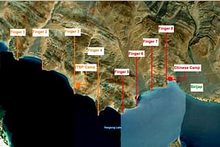
To understand why the operation mattered, one must first understand the terrain. The Kailash Range runs almost perpendicular to the southern bank of the Pangong Lake, a 134-kilometre brackish water body that straddles the Line of Actual Control.
To the east of the range lies Spanggur Tso, a lake that India claims but China effectively controls. To the west lies the Chushul Valley and, critically, the approaches to Chushul village which sits on the road to Leh.
The tactical geography centres on the Spanggur Gap, a nearly three-kilometre-wide break in the mountain chain at approximately 4,900 metres elevation.
This flat terrain allows the deployment of armoured elements. China had constructed roads right up to the gap. These roads link the Chinese bases around the Spanggur Gap with the Tibet-Xinjiang Highway (Highway 219) in the Tibetan town of Rudok further east.
In any future conflict, this gap would be the most viable route for a Chinese armoured thrust toward Chushul and ultimately Leh.
The heights on the Kailash Range, including Gurung Hill, Magar Hill, Mukhpari, Rezang La, and Rechin La, are the dominating features overlooking both the Spanggur Gap and Chinese positions around Moldo Garrison. Control of these heights means control of the approaches to Chushul. Lose them, and the door to Ladakh swings open.
By August 2020, the standoff that had begun in April-May had reached an impasse. Chinese forces had occupied territory on the north bank of Pangong Tso, pushing from their position near Finger 8 to Finger 4. Five rounds of Corps Commander-level talks had yielded nothing.

The brutal clash at Galwan Valley on 15 June, which killed 20 Indian soldiers and an estimated 45 Chinese, had shattered whatever trust existed between commanders on the ground. Lieutenant General YK Joshi, who commanded the Fire and Fury Corps during the crisis, later noted that before the Kailash Range operation, India was "on the back foot" with no leverage to compel Chinese withdrawal.
The problem was straightforward: any military attempt to dislodge Chinese forces from their occupied positions on the north bank risked dangerous escalation. India needed leverage elsewhere. The Kailash Range offered that opportunity.
The Operation And Its Logic
Intelligence on 29 August revealed Chinese troops moving toward Black Top and Helmet Top, two features on the Kailash Range. The pattern was familiar. The same creeping aggression that had characterised Chinese actions since April. But this time, India moved first.
On the morning of 30 August, Lt Gen Joshi realised the Chinese might attempt to seize additional heights and contacted Army Chief Naravane for immediate clearance.
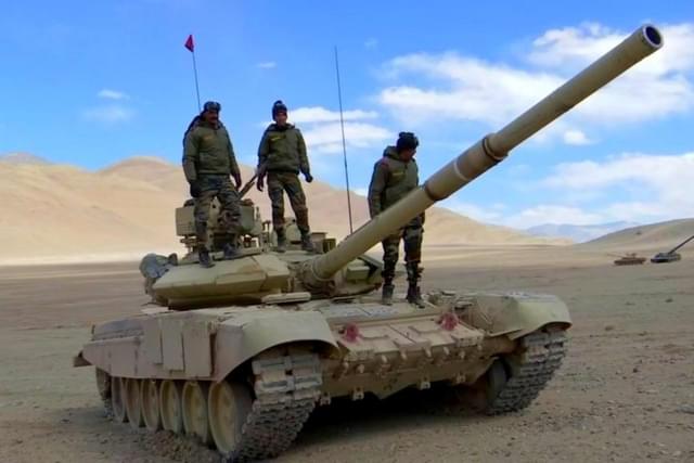
What followed was a race against time. Troops from the elite Para Special Forces, elements of the Mountain Strike Corps, and commandos from the Special Frontier Force, the secretive unit manned by ethnic Tibetan volunteers, rushed onto Mukhpari, Rezang La, and Rechin La, some movements occurring in broad daylight.
The tactical logic was sound. From these heights, Indian forces now had complete observation of Chinese camps, supply lines, and the Moldo Garrison. Armed with Milan anti-tank missiles and Carl Gustav rocket launchers, soldiers on these peaks rendered Chinese tanks at Moldo effectively redundant.
As one analyst noted, the garrison was "virtually under siege". Any armoured movement through the Spanggur Gap would face withering fire from multiple directions.
The operation created what this author had earlier called a "mountain-range sized bargaining chip." India now controlled features it had not held for 58 years, overlooking territory China considered secure. The asymmetry of the standoff had been upended.
Before August 29-30, China held Indian territory on the north bank with India having no equivalent leverage. After the operation, both sides had something the other wanted.
The Chinese response was immediate. By the evening of 31 August, four Chinese tanks with infantry began advancing toward Rechin La.
By 10:10 PM, they were 500 metres from the pass. Indian tanks had been raced to the peaks. Satellite imagery would later show Indian and Chinese armour positioned less than 500 feet apart. Lt Gen Joshi would later describe this as the moment when "war was actually averted" but both sides were "absolutely on the brink." The discipline required to not fire, he noted, demanded more courage than pulling the trigger.
The tense stand-off that night eventually de-escalated. But the Chinese calculus had changed. Within months, after the ninth round of Corps Commander talks in January 2021, Beijing agreed to withdraw from the north bank of Pangong Tso in exchange for India vacating the Kailash Range heights.
The disengagement, announced in February 2021, restored status quo ante April 2020 on both banks, precisely the outcome India had sought through multiple fruitless rounds of talks before the operation.
Lesson From History
The Chushul sub-sector saw heavy fighting during the 1962 war as the two sides wrestled to take control of the heights on the Kailash Range.
Expecting a Chinese attack towards Chushul through the Spanggur Gap, the Indian Army had ordered the deployment of AMX-13 tanks of the 20 Lancers.
Six tanks were airlifted from Chandigarh on the Indian Air Force’s An-12 transport aircraft of 44 Squadron, which had been inducted just months ago in 1961.
Tanks arrived on 25 and 26 October as the An-12s landed on the Chushul Airfield located immediately west of the Spanggur Gap and were deployed at the base of the Gurung Hill to deny the Spanggur Gap to the PLA.
Gurung Hill, Spanggur Gap and the Chushul Airfield were being defended by troops, only one company each, from 1/8 Gorkha Rifles. One company of 13 Kumaon was defending Magar Hill, and one company and a section was present at Rezang La.
Positions around Gurung Hill and Magar Hill, located north and south of the Spanggur Gap, had limited artillery support, which was further limited by its range.
At Rezang La, troops fought in a battle still remembered without artillery support.
When the Chinese attack came in the early hours of 18 November, ill-prepared for the fight, faced with fierce Chinese attacks coming in waves and losses mounting, India decided to withdraw troops in the region to heights west of the Chushul Valley.
The Indian Army’s withdrawal to the west left the tactically-important heights on the Kailash Range unoccupied and Chushul airfield abandoned, giving China the opportunity to occupy Indian territory east of the Kailash Range.

It left the possibility of Chinese thrust from the Spanggur Gap towards Chushul and Leh open in the event of a war between the two countries, and left India’s defences vulnerable.
Indian troops couldn’t return to the heights on the Kailash Range to hold them for over 50 years, until the intervening night of 29 and 30 August in 2020.
Prakhar Gupta (@prakharkgupta) is a senior editor at Swarajya.